The Planning Continues...
I have been on several day and overnight hikes since I last wrote but the App I use to blog from my iphone was not working after the last update so I was unable to blog. I spent a lot of time trying to figure out the problem only to find it was an App problem. It is now fixed and I am back in business. I have posted new heart healthy info under the heart healthy information tab - check it out.
Now to catch you up on my planning progress...
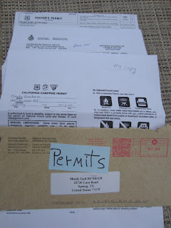
I mailed out my applications for my permits in January and had them back in two weeks!
To hike the PCT three permits are needed. One permit covers hiking the PCT. There is no charge for this permit unless you also want to hike Mt Whitney ($15). Since I hiked Mt Whitney last August I probably won't hike it again but I did get the permit just in case.
The second permit is a Campfire Permit. You must have a California Campfire Permit to use a stove, lantern, or campfire outside a developed campground or recreation area. The permit is your agreement to follow the campfire restrictions and regulations in effect. You print your permit yourself from the PCT website. There is no charge for this permit.
The third permit needed is permission to enter Canada. You can obtain this permit from the PCT website as well and at no charge.
Using Yogi's PCT Handbook (pictured above) I put my map packs together for each of the 28 sections and placed them in ZipLock bags. I will distribute these packs in my resupply boxes and my husband will send them to designated trail towns. It takes a lot of planning but there are numerous resources to help. Yogi's Planning Guide and Handbook, Half-mile Maps and the three PCT guidebooks include all you need to know to plan your way. Of course there will be unforseen detours but you just have to cross thoses bridges (or get around those blow downs) when you get to them. Blow downs are trees that have fallen and have blocked the path. Climbing over them is exhausting and some times impossible. Going around them takes you off trail and ofter makes it even difficult to find the trail again.
This year it looks like the detours may entail the blow downs from the high winds experienced in the Sierras in November 2011. Reports from the U.S. Forest Service say the tangle of trees resembles “a giant’s game of pick-up sticks.” Winds well in excess of 150 miles per hour were recorded, often registering “off the chart” gusts on monitoring equipment at the top of Mammoth Mountain Ski Area.
According to an article posted by Andy Geisel on Feb 20, 2012 in Arts and Life, News
there are, he said, hundreds of trees in 10-foot-high piles. Everything in a SW aspect was hit, and the patterning seems to fall within the 7,500 feet to 9,000 feet timberline. Farley said the wind took out a lot of “sailors,” which are often the biggest and oldest trees that have large canopies, those resembling “sails.”
Not unlike tornado damage, the event’s randomness is both perplexing and yet awesome in the level of devastation. “There are at least 2,000 to 3,000 trees down that we know of,” Morse related. “The volunteers stopped counting after 800 trees and had only gone 3 miles.”
Every year brings challenges to PCT hikers. Last year it was the snow, some years the fires, drought, or storms. No two years are the same. It truly is an unpredictable adventure. I look forward to the challenges ahead and hope to be able to share them with you along the way.
Happy Trails
Heart


